 South Community Area Plan: Survey #2
South Community Area Plan: Survey #2
The City of San Antonio Planning Department is gathering community input to improve the vision, goals, and focus areas for the South Community Area Plan ("Plan"). We are also gathering community input on the preliminary Future Land use Map to determine what should be evaluated and refined as we continue with the planning process. Please submit your feedback by completing the survey by Sunday, November 20, 2022. For any questions, please email Carlos Guerra, Project Manager for the South Community Area Plan at: Carlos.Guerra2@sanantonio.gov.
El Departamento de Planificación de la Ciudad de San Antonio está reuniendo aportes de la comunidad para mejorar la visión, las metas y las áreas de enfoque para el Plan del Área Comunitaria South ("Plan"). También estamos recopilando información de la comunidad sobre el Mapa preliminar de uso futuro de la tierra para determinar qué se debe evaluar y refinar a medida que continuamos con el proceso de planificación. Envíe sus comentarios completando la encuesta antes del domingo 20 de noviembre del 2022 . Si tiene alguna pregunta, envíe un correo electrónico a Iris Gonzalez, Gerente de Proyectos Especiales a: Iris.Gonzalez@sanantonio.gov.
Currently in Stage 1: Community Engagement
Stage 1: Community Engagement
Community Engagement / Participación de la comunidad
This survey is will be open until Sunday, November 20, 2022. Thank you for taking the time to make sure your voice is heard for your city!
Esta encuesta estará abierta hasta el domingo 20 de noviembre del 2022 . ¡Gracias por su tiempo y por asegurarse de que se escuche su voz en su ciudad!
The City of San Antonio's Planning Department is requesting responses to this survey in order to gather community input that will be used to refine the Focus Areas and Future Land Use Map for the South Community Area Plan ("Plan").
The Plan will guide development and City decisions and investments over the next 10 years. The content of the Plan will address the following topics:
- Economic Development
- Housing
- Infrastructure and Public Space
- Land Use and Development
- Neighborhood Priorities
- Parks and Trails
- Transformative Projects
- Transportation
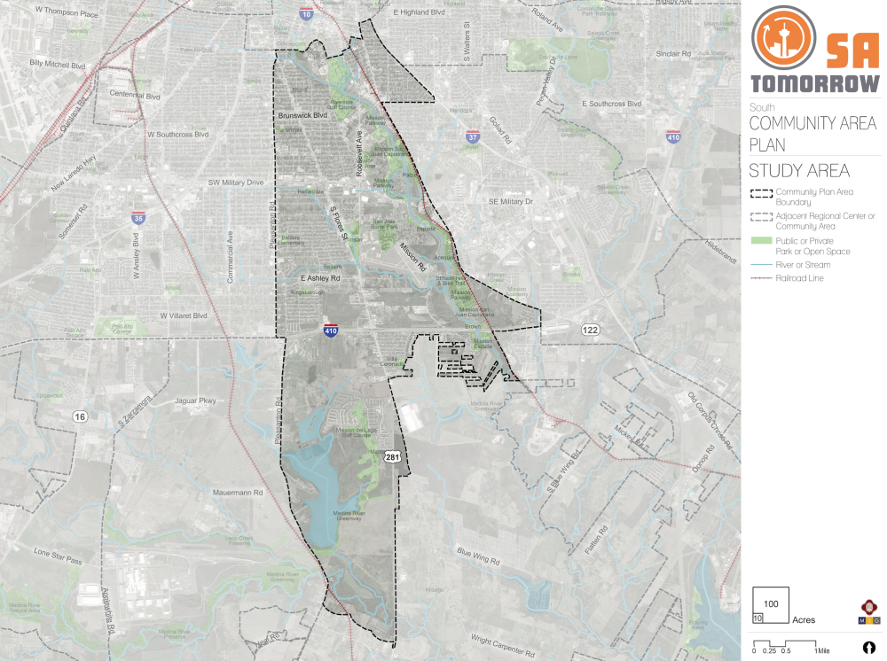
The boundaries of the Plan area are shown on the map below. Please reference this map when answering questions.
El Departamento de Planificación de la Ciudad de San Antonio está solicitando respuestas a esta encuesta para recopilar aportes de la comunidad que se utilizarán para refinar las Áreas de Enfoque y el Mapa de Uso Futuro de la Tierra para el Plan del Área Comunitaria South ("Plan").
El Plan guiará las decisiones e inversiones de desarrollo y de la Ciudad durante los próximos 10 años. El contenido del Plan abordará los siguientes temas:
- Desarrollo economico
- Vivienda
- Infraestructura y Espacio Público
- Uso y desarrollo de la tierra
- Prioridades del vecindario
- Parques y Senderos
- Proyectos Transformadores
- Transportación
Los límites del área del Plan se muestran en el siguiente mapa. Consulte este mapa cuando responda las preguntas
Draft Vision
The draft Vision for the South Community Area was created using community input. Please review the draft Vision below:
The South Community Area helps multi-generational households, residents, and businesses thrive by respecting, celebrating, and connecting the area's rich history and authenticity, community destinations and gathering places, and family friendly recreational amenities with clean and green infrastructure.
Borrador de la visión
El borrador de la Visión para el Área Comunitaria South se creó utilizando los aportes de la comunidad. Por favor revise el borrador de la visión a continuación:
El Área Comunitaria South ayuda a los hogares, residentes y negocios multigeneracionales a prosperar respetando, celebrando y conectando la historia y autenticidad del área, los destinos comunitarios y los lugares de reunión, y las amenidades recreativas para toda la familia con una infraestructura limpia y ecológica.
Draft Goals
The draft Goals for the South Community Area were created using community input. Please review the draft Goals below:
- Improve comfort and safety through urban greening and integration of sustainable infrastructure
- Promote quality development that is compatible with existing neighborhoods and includes additional housing and employment options for existing and new residents.
- Attract and grow clean industries with well-paying, quality jobs for local residents.
- Leverage heritage tourism and ecotourism to grow existing and new small businesses.
- Support and cultivate retention and growth of artists, makers and the creative class.
- Increase access to healthy food, health care and recreational amenities for all residents.
- Utilize existing mobility routes to create multi-modal connectivity and transportation options from the South Community Area to major hubs in the City.
Borrador de los objetivos
El borrador de los objetivos para el Área Comunitaria South se creó utilizando los aportes de la comunidad. Revise el borrador de los objetivos a continuación:
- Mejorar la comodidad y la seguridad a través de la ecologización urbana y la integración de infraestructura sostenible.
- Promover un desarrollo de calidad que sea compatible con los vecindarios existentes e incluya opciones adicionales de vivienda y empleo para residentes nuevos y existentes.
- Atraer y hacer crecer industrias verdes con empleos de calidad y bien remunerados para los residentes locales.
- Aprovechar el turismo de nuestro patrimonio, asi como el ecoturismo para hacer crecer tanto las pequeñas empresas existentes, como las nuevas.
- Apoyar y cultivar la retención y el crecimiento de artistas, creadores y la clase creativa.
- Aumentar el acceso a alimentos saludables, atención médica y servicios recreativos para todos los residentes.
- Utilizar las rutas de movilidad existentes para crear conectividad multimodal y opciones de transporte desde el Área Comunitaria South hasta los principales centros de la ciudad.
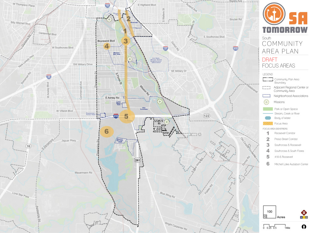
Draft Focus Areas
Focus areas are, or will be, important areas of opportunity to direct future investments, support, or improvements. Focus areas were initially identified using community input. Your answers to the questions below will help us refine focus areas for the South Community Area. The map below shows a total of six proposed focus areas for the South Community Area, which are as follows:
1. Roosevelt Corridor
2. Presa Street Corridor
3. Southcross & Roosevelt
4. Southcross & South Flores
5. 410 & Roosevelt
6. Mitchell Lake Audobon Center
Borrador de áreas de enfoque
Las áreas de enfoque son, o serán, importantes áreas de oportunidad para dirigir futuras inversiones, apoyo o mejoras. Las áreas de enfoque se identificaron inicialmente utilizando los aportes de la comunidad. Sus respuestas a las siguientes preguntas nos ayudarán a refinar las áreas de enfoque para el Área Comunitaria South. El siguiente mapa muestra un total de seis áreas de enfoque propuestas para el Área Comunitaria South, que son las siguientes:
1. Corredor Roosevelt
2. Corredor de la Calle Presa
3. Southcross y Roosevelt
4. Southcross y South Flores
5. 410 y Roosevelt
6. Centro Mitchell Lake Audobon
Working Draft Future Land Use Map
Land use is a term to describe the uses that exist or are envisioned on a property. It is generally broken down into categories, such as:
- Residential (e.g. houses, duplexes, apartments)
- Commercial (e.g. stores, restaurants, offices)
- Industrial (e.g. manufacturing, distribution facilities)
- Mixed-Use (e.g. stores on first level and apartments above or retail and homes on the same property)
- Government and Parks/Open Space (e.g. public parks, government facilities)
The Future Land Use Map identifies how land can be used in the future. It defines how a property can be rezoned in the future, it sets guides for elected officials deciding rezoning cases, it ensures that project growth can be absorbed in an orderly way throughout the City, and it establishes the preferred mixtures of uses and the distribution of density in various areas of the City, based on public input and feedback.
Borrador del Mapa de Uso Futuro de la Tierra
El uso de la tierra es un término para describir los usos que existen o se prevén en una propiedad. Generalmente se divide en categorías, tales como:
- Residencial (por ejemplo, casas, dúplex, apartamentos)
- Comercial (por ejemplo, tiendas, restaurantes, oficinas)
- Industrial (p. ej., fabricación, instalaciones de distribución)
- Uso mixto (p. ej., tiendas en el primer nivel y apartamentos arriba o tiendas y casas en la misma propiedad)
- Gobierno y parques/espacios abiertos (p. ej., parques públicos, instalaciones gubernamentales)
El Mapa de uso futuro de la tierra identifica cómo se puede usar la tierra en el futuro. Define cómo se puede rezonificar una propiedad en el futuro, establece guías para los funcionarios electos que deciden casos de rezonificación, asegura que el crecimiento del proyecto se pueda absorber de manera ordenada en toda la Ciudad y establece las mezclas preferidas de usos y la distribución de densidad en varias áreas de la Ciudad, con base en los aportes y comentarios del público.
The document section includes a PDF version of the Work Draft Future Land Use Map along with full size aerial images for each focus area.
La sección del documento incluye una versión en PDF del Borrador del Mapa de Uso Futuro de la Tierra junto con imágenes aéreas de tamaño completo para cada área de enfoque.
Optional Questions: The next set of questions are optional. Your responses will remain anonymous. / Preguntas opcionales: El siguiente conjunto de preguntas son opcionales. Sus respuestas permanecerán anónimas.
Optional Questions: The next set of optional questions will help us improve our outreach efforts across the City. The information you share helps us better understand how your lived experiences contribute to your experience and perceptions in this survey. Your responses will remain anonymous.
Preguntas opcionales: El siguiente conjunto de preguntas opcionales nos ayudará a mejorar nuestros esfuerzos de divulgación en toda la ciudad. La información que comparta nos ayudará a entender mejor cómo sus experiencias vividas contribuyen a su experiencia y percepciones en esta encuesta. Sus respuestas serán anónimas.