 Greater Airport Area Regional Center: Survey #2
Greater Airport Area Regional Center: Survey #2
The City of San Antonio Planning Department gathered community input to improve the vision, goals, and focus areas for the Greater Airport Area Regional Center Plan ("Plan"). We also gathered community input on the preliminary Future Land use Map to determine what should be evaluated and refined as we continue with the planning process. For any questions, please email Jacob Howard, Project Manager for the Greater Airport Area Regional Center Plan at: Jacob.Howard@sanantonio.gov.
El Departamento de Planificación de la Ciudad de San Antonio reunio aportes de la comunidad para mejorar la visión, las metas y las áreas de enfoque para el Plan del Centro Regional del Área de Greater Airport ("Plan"). También reunimos información de la comunidad sobre el Mapa preliminar de uso futuro de la tierra para determinar qué se debe evaluar y refinar a medida que continuamos con el proceso de planificación. Si tiene alguna pregunta, envíe un correo electrónico a Iris Gonzalez, Gerente de Proyectos Especiales a: [email protected].
Currently in Stage 2: Under Review
Community Engagement / Participación de la comunidad
Thank you for taking the time to make sure your voice is heard for your city!
¡Gracias por su tiempo y por asegurarse de que se escuche su voz en su ciudad!
The City of San Antonio's Planning Department is requesting responses to this survey in order to gather community input that will be used to refine the Focus Areas and Future Land Use Map for the Greater Airport Area Regional Center Plan ("Plan").
The Plan will guide development and City decisions and investments over the next 10 years. The content of the Plan will address the following topics:
- Economic Development
- Housing
- Infrastructure and Public Space
- Land Use and Development
- Neighborhood Priorities
- Parks and Trails
- Transformative Projects
- Transportation
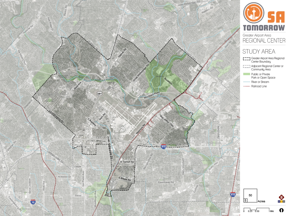
The boundaries of the Plan area are shown on the map. Please reference this map when answering questions.
El Departamento de Planificación de la Ciudad de San Antonio está solicitando respuestas a esta encuesta para recopilar aportes de la comunidad que se utilizarán para refinar las Áreas de Enfoque y el Mapa de Uso Futuro de la Tierra para el Plan del Centro Regional del Área de Greater Airport ("Plan").
El Plan guiará las decisiones e inversiones de desarrollo y de la Ciudad durante los próximos 10 años. El contenido del Plan abordará los siguientes temas:
- Desarrollo economico
- Vivienda
- Infraestructura y Espacio Público
- Uso y desarrollo de la tierra
- Prioridades del vecindario
- Parques y Senderos
- Proyectos Transformadores
- Transportación
Los límites del área del Plan se muestran en el siguiente mapa. Consulte este mapa cuando responda las preguntas
Draft Vision
The draft Vision for the Greater Airport Area Regional Center was created using community input. Please review the draft Vision:
The Greater Airport Area Regional Center is a successful employment center with a variety of small and large businesses, including shops, restaurants, and entertainment venues, that serve the area’s diverse and safe neighborhoods, the City, and are compatible with Airport operations. Residents and visitors enjoy a well-distributed and maintained parks, open space, and trail system, and complete streets with safe and comfortable pedestrian, bicycle and transit options.
Borrador de la visión
El borrador de la Visión para el Centro Regional del Área de Greater Airport se creó utilizando los aportes de la comunidad. Por favor revise el borrador de la visión:
El Centro Regional del Área Greater Airport es un centro de empleo exitoso con una variedad de pequeñas y grandes empresas, incluidas tiendas, restaurantes y lugares de entretenimiento, que sirven a los diversos y seguros vecindarios del área, la Ciudad, y que son compatibles con las operaciones del Aeropuerto. Los residentes y visitantes disfrutan de parques, espacios abiertos y Sistema de senderos bien distribuidos y mantenidos, y calles completas con opciones seguras y cómodas para peatones, ciclistas y tránsito.
Draft Goals
The draft Goals for the Greater Airport Area Regional Center were created using community input. Please review the draft Goals:
Goal 1: Create safe and vibrant destinations with a diversity of strategically located and high-quality housing, employment, and mixed-use developments that respects existing neighborhoods and avoid conflict with the Airport.
Goal 2: Improve existing streets and create new connections that are truly multimodal, aesthetically pleasing and provide stormwater benefits.
Goal 3: Increase equitable access to parks, open space, trails and recreational amenities throughout the Regional Center.
Goal 4: Address safety concerns and barriers created by transportation infrastructure of all types throughout the Regional Center.
Goal 5: Improve comfort, safety and aesthetics throughout the Regional Center with trees, other urban greening, and integration of sustainable infrastructure.
Goal 6: Enhance transit connections to amenities within the Greater Airport Regional Center, to Downtown, and to other Regional Centers in and outside of San Antonio for residents, employees, and visitors.
Goal 7: Promote quality infill development and redevelopment within neighborhoods and commercial areas that are compatible with existing homes and provides more housing options for existing and new residents.
Goal 8: Suggest an additional Goal below.
Borrador de los objetivos
El borrador de los objetivos para el Área del Centro Regional de Greater Airport se creó utilizando los aportes de la comunidad. Revise el borrador de los objetivos:
Objetivo 1: Crear destinos seguros y vibrantes con una diversidad de viviendas, empleos y desarrollos de uso mixto estratégicamente ubicados y de alta calidad que respeten los vecindarios existentes y eviten conflictos con el aeropuerto.
Objetivo 2: Mejorar las calles existentes y crear nuevas conexiones que sean verdaderamente multimodales, estéticamente agradables y que brinden beneficios para las aguas pluviales.
Objetivo 3: Aumentar el acceso equitativo a parques, espacios abiertos, senderos y servicios recreativos en todo el Centro Regional.
Objetivo 4: Abordar las preocupaciones de seguridad y las barreras creadas por lainfraestructura de transporte de todo tipo en todo elCentro Regional.
Objetivo 5: Mejorar la comodidad, la seguridad y la estética en todo el Centro Regional con árboles, otras áreas verdes urbanas e integración de infraestructura sostenible.
Objetivo 6: Mejorar las conexiones de tránsito a los servicios dentro del Centro Regional del Greater Airport, al Centro y a otrosCentros Regionales dentro y fuera de San Antonio para residentes, empleados y visitantes.
Objetivo 7: Promover el desarrollo de calidad dentro de barrios y áreas comerciales que soncompatible con las viviendas existentes y brinda más opciones de vivienda para los residentes existentes y nuevos.
Objetivo 8: Sugerir objetivos adicionales a continuación.
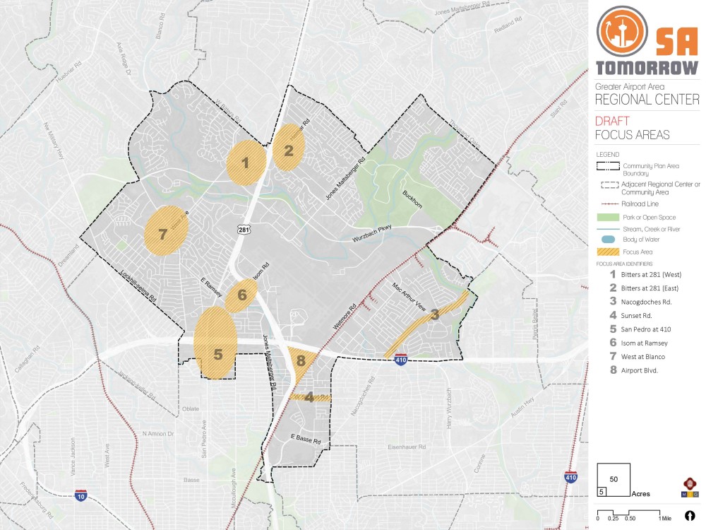
Draft Focus Areas
Focus areas are, or will be, important areas of opportunity to direct future investments, support, or improvements. Focus areas were initially identified using community input. Your answers to the questions will help us refine focus areas for the Greater Airport Area Regional Center. The map shows a total of eight proposed focus areas for the Greater Airport Area Regional Center, which are as follows:
- Bitters at 281 (West)
- Bitters at 281 (East)
- Nacogdoches Road
- Sunset Road
- San Pedro at 410
- Isom at East Ramsey
- West at Blanco
- Airport Blvd.
Borrador de áreas de enfoque
Las áreas de enfoque son, o serán, importantes áreas de oportunidad para dirigir futuras inversiones, apoyo o mejoras. Las áreas de enfoque se identificaron inicialmente utilizando los aportes de la comunidad. Sus respuestas a las siguientes preguntas nos ayudarán a refinar las áreas de enfoque para el Área de Greater Airport. El siguiente mapa muestra un total de ocho áreas de enfoque propuestas para el Área de Greater Airport, que son las siguientes:
- Bitters y 281 (Oeste)
- Bitters y 281 (Este)
- Calle Nacogdoches
- Calle Sunset
- San Pedro y 410
- Isom y East Ramsey
- West y Blanco
- Airport Blvd.
Working Draft Future Land Use Map
Land use is a term to describe the uses that exist or are envisioned on a property. It is generally broken down into categories, such as:
- Residential (e.g. houses, duplexes, apartments)
- Commercial (e.g. stores, restaurants, offices)
- Industrial (e.g. manufacturing, distribution facilities)
- Mixed-Use (e.g. stores on first level and apartments above or retail and homes on the same property)
- Government and Parks/Open Space (e.g. public parks, government facilities)
The Future Land Use Map identifies how land can be used in the future. It defines how a property can be rezoned in the future, it sets guides for elected officials deciding rezoning cases, it ensures that project growth can be absorbed in an orderly way throughout the City, and it establishes the preferred mixtures of uses and the distribution of density in various areas of the City, based on public input and feedback.
Borrador del Mapa de Uso Futuro de la Tierra
El uso de la tierra es un término para describir los usos que existen o se prevén en una propiedad. Generalmente se divide en categorías, tales como:
- Residencial (por ejemplo, casas, dúplex, apartamentos)
- Comercial (por ejemplo, tiendas, restaurantes, oficinas)
- Industrial (p. ej., fabricación, instalaciones de distribución)
- Uso mixto (p. ej., tiendas en el primer nivel y apartamentos arriba o tiendas y casas en la misma propiedad)
- Gobierno y parques/espacios abiertos (p. ej., parques públicos, instalaciones gubernamentales)
El Mapa de uso futuro de la tierra identifica cómo se puede usar la tierra en el futuro. Define cómo se puede rezonificar una propiedad en el futuro, establece guías para los funcionarios electos que deciden casos de rezonificación, asegura que el crecimiento del proyecto se pueda absorber de manera ordenada en toda la Ciudad y establece las mezclas preferidas de usos y la distribución de densidad en varias áreas de la Ciudad, con base en los aportes y comentarios del público.
The document section includes a PDF version of the Working Draft Future Land Use Map along with full size aerial images for each focus area.
La sección del documento incluye una versión en PDF del Borrador del Mapa de Uso Futuro de la Tierra junto con imágenes aéreas de tamaño completo para cada área de enfoque.
Optional Questions: The next set of questions are optional. Your responses will remain anonymous. / Preguntas opcionales: El siguiente conjunto de preguntas son opcionales. Sus respuestas permanecerán anónimas.
Optional Questions: The next set of optional questions will help us improve our outreach efforts across the City. The information you share helps us better understand how your lived experiences contribute to your experience and perceptions in this survey. Your responses will remain anonymous.
Preguntas opcionales: El siguiente conjunto de preguntas opcionales nos ayudará a mejorar nuestros esfuerzos de divulgación en toda la ciudad. La información que comparta nos ayudará a entender mejor cómo sus experiencias vividas contribuyen a su experiencia y percepciones en esta encuesta. Sus respuestas serán anónimas.